Probable Reasons for Bulletin 120 Forecast Errors in Water Year 2023
Water year (WY) 2023 posed a new set of challenges never before experienced as California continued its climate whiplash from extreme dry to extreme wet. Above-average precipitation and snow was recorded across California’s hydrologic regions leading to replenished reservoirs and a wetter landscape. The water year also presented challenges, including increased risk of flooding and the need for efficient water management. However, a parade of atmospheric rivers led to significant precipitation and snow accumulation offered relief to the persistent drought of 2020-2022. These factors, coupled with improved water supply forecasts, helped mitigate the impacts of the ongoing drought. The Department of Water Resources continued its investments in observations, forecasting tools, and decision support capabilities, highlighting the Department's dedication to managing its water resources sustainably. Overall, while WY2023 had its share of difficulties, it also showcased the Department’s adaptability and resilience amidst evolving climatic conditions.
Overall, the Bulletin 120 seasonal water supply forecasts demonstrated remarkable accuracy regardless of how wet the water year turned out to be. The forecasts provided by the Snow Surveys and Water Supply Forecasting Unit continued to close in on observed April-July unimpaired runoff volumes as the year progressed. In fact, percent error for the median (50% exceedance) forecast for the April 1, 2023 Bulletin 120 for the Feather River watershed was 0.53%. That means the Snow Surveys and Water Supply Forecasting Unit forecasted an April-July unimpaired volume of 3.2 million acre-feet, and 3.217 million acre-feet was observed for a difference of 17 thousand acre-feet. This high level of precision and skill can be attributed to advancements DWR has made in forecasting methodologies, refined modeling techniques, implementation of proven technologies, and improved data collection methods. The Bulletin 120 forecasts provided water resource managers and interested parties invaluable insights for planning and decision-making during a record-breaking snowpack year which resulted in the re-emergence of Tulare Lake. This success underscores the State's commitment to enhancing its water supply forecasting capabilities, ensuring a more sustainable and resilient future in the face of a changing climate.
Although Bulletin 120 forecasts proved to be accurate in WY2023, forecasting errors will always be present due to climate uncertainty, modeling limitations, data scarcity, and more. Listed below are potential reasons that may have caused forecast error for the Bulletin 120.
Climate and Weather Anomalies
Lack of Precipitation During Spring 2023
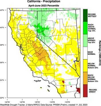
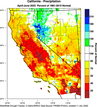
Starting in WY2023, Bulletin 120 forecasts incorporated the California-Nevada River Forecast Center’s 6-day precipitation forecast appended with climatology for the remainder of the forecast window. For the April 1 Bulletin 120 forecast, DWR’s model ingested observed and forecasted precipitation through April 10, 2023, and then used climatology for the remainder of the forecast window to forecast seasonal April-July unimpaired runoff. April and May 2023 were historically dry, according to the San Joaquin 5-Station Precipitation Index, receiving only 1.03 inches of precipitation over these two months. In comparison, on average, the San Joaquin 5-Station Precipitation Index receives of 6.3 and 3.5 inches in April and May, respectively. This is the 4th driest April and May period dating back to 1913. This difference in expected precipitation versus actual precipitation pushed the Bulletin forecast closer to the 90% exceedance forecast rather than the median (50%) predicted April 1 forecast.
Below Average Temperatures During Snowmelt Period
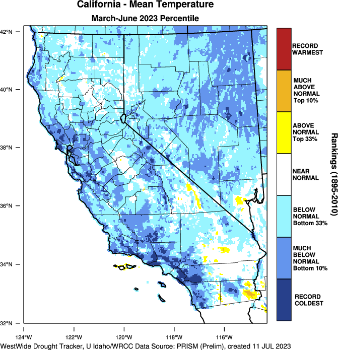
Bulletin 120 models incorporate seasonal climatology for forecasted conditions, however WY2023 was unseasonably cool during the spring and summer impacting the snowpack and subsequent snowmelt patterns. Monthly forecasted unimpaired flow volumes did not occur as predicted even while measurements from the Aerial Remote Sensing of Snow Program determined that high elevation snowpack was deeper and contained more water that lasted longer into the summer than initially predicted. This inevitably led to snow losses due to ablation but more importantly large amounts of snow that carried over into the next water year or melted beyond the forecast period (April-July). The extended snowmelt period played a crucial role for flood risk in the San Joaquin and Tulare Lake Hydrologic Regions. Coupled with the lack of spring precipitation, it provided extra time that enabled reservoir operators to vacate storage to make room for the near-record breaking snowmelt that would eventually be captured to refill the reservoirs by mid-summer.
Weather Anomalies Forecast Improvements
While DWR has made great strides in ingesting 6-day precipitation forecasts from the CNRFC, seasonal climate variability such as the historically dry Spring 2023 can be a substantial source of runoff forecast error. For runoff forecasts, future weather is the single largest source of uncertainty and thus the largest source of forecast error. With the likelihood of seasonal climate variability increasing, DWR is committed to working with its research partners such as the Center for Western Weather and Water Extremes (CW3E) to further develop and refine subseasonal-to-seasonal precipitation and temperature forecasts and developing methods to ingest these forecasts into the Bulletin 120. Lessons learned from WY2023 can be used to help understand how in a large snowpack year, shorter periods of anomalous weather patterns such as the dry and cool conditions during the spring impact snowmelt runoff rates and overall runoff volumes. As subseasonal and season climate forecasts demonstrate more skill and become more reliable in quantifying future weather uncertainty, DWR will be able to utilize the information to help water managers better understand and quantify the range of uncertainty in runoff forecasts.
Hydrometerological Observations
Soil Moisture: Dry Antecedent Conditions From 2020-2022 Drought
While WY2022 started wet, the January-March combined precipitation in 2022 was the driest on record dating back over a century. This led California to another below average snowpack for a third straight year deepening the ongoing drought. The severe and extended drought conditions persisted leading to further aridification of the landscape and decreased river base flows entering the water supply forecast season. Antecedent conditions were accounted for by modelers, but the direct impact cannot be specifically quantified due to the lack of a soil moisture sensor network in the Sierra Nevada and Southern Cascades. Based on the limited station-based soil moisture data available, soil moisture was well below average to start WY2023 until it finally improved after the barrage of atmospheric rivers that first made landfall along the California coast in late December 2022.
Soil Moisture Forecast Improvements
If future weather is the largest source of uncertainty and error in runoff forecasts, quantifying the physical state of the watershed such as soil moisture conditions through observations is a key variable in runoff forecasting. Without a doubt, the drying effects on soil moisture from the 2020-2022 drought were profound throughout the state, including in the Sierra Nevada and Southern Cascade mountains. Quantifying how much effect the arid conditions had on runoff during the past decade continues to be the challenge because of the lack of soil moisture sensors in the upper watersheds. The swing from extreme dry to extreme wet during WY2023 helped DWR understand how quickly soil moisture conditions can improve during prolonged atmospheric river periods such as those that occurred in WY2023. Likewise, the intense warm and dry periods during the summer and fall of 2023 demonstrated how fast soil moisture can diminish. Without a network of soil moisture sensors to rely upon, DWR and its partners continue to develop models that estimate soil moisture conditions in all Sierra Nevada and Southern Cascade headwaters. Knowledge gained during WY2022 and WY2023 will aid in developing products and information from these models that can be used to inform runoff forecasts in future years. The shift from extreme dry soil moisture conditions in the fall of 2022 to wet conditions by the spring of 2023 emphasized the need for DWR to have access to more frequently updated soil moisture modeling products. Meanwhile, DWR will continue to work with regulatory agencies such as the US Forest Service (USFS) and National Park Service (NPS) to obtain special use permits to install soil moisture sensors at monitoring stations in the upper watersheds. Careful study must be made to determine where deploying soil moisture sensors will provide the greatest benefit while thorough environmental, cultural, and archeological analyses must be performed in order to obtain permits to install sensors.
Snowpack: Accuracy in In-Situ Snowpack Measurements During High Snowpack Years
WY2023 experienced several events with low elevation snowfall. The Bulletin 120 modeling procedures utilize snow water equivalent data from several station-based point locations within each watershed such as snow courses and snow sensors. The amount of snow water equivalent is normalized utilizing a ratio based on that location’s historic April 1 average. The low elevation snowfall both impacted areas where the Bulletin 120 modeling procedures had no coverage and also skewed results in low elevation stations by recording snow totals that were so much higher than the historical average. At times, several low elevation snow sensors recorded over 1000% of average snow water equivalent due to the highly variable low elevation snow. These anomalous conditions impacted the Bulletin 120 modeling procedures and produced results that appeared to be higher than expected and reasonable. The Snow Surveys and Water Supply Forecasting Unit used forecaster’s knowledge, skill, and experience to adjust input data in an effort to improve forecast accuracy.
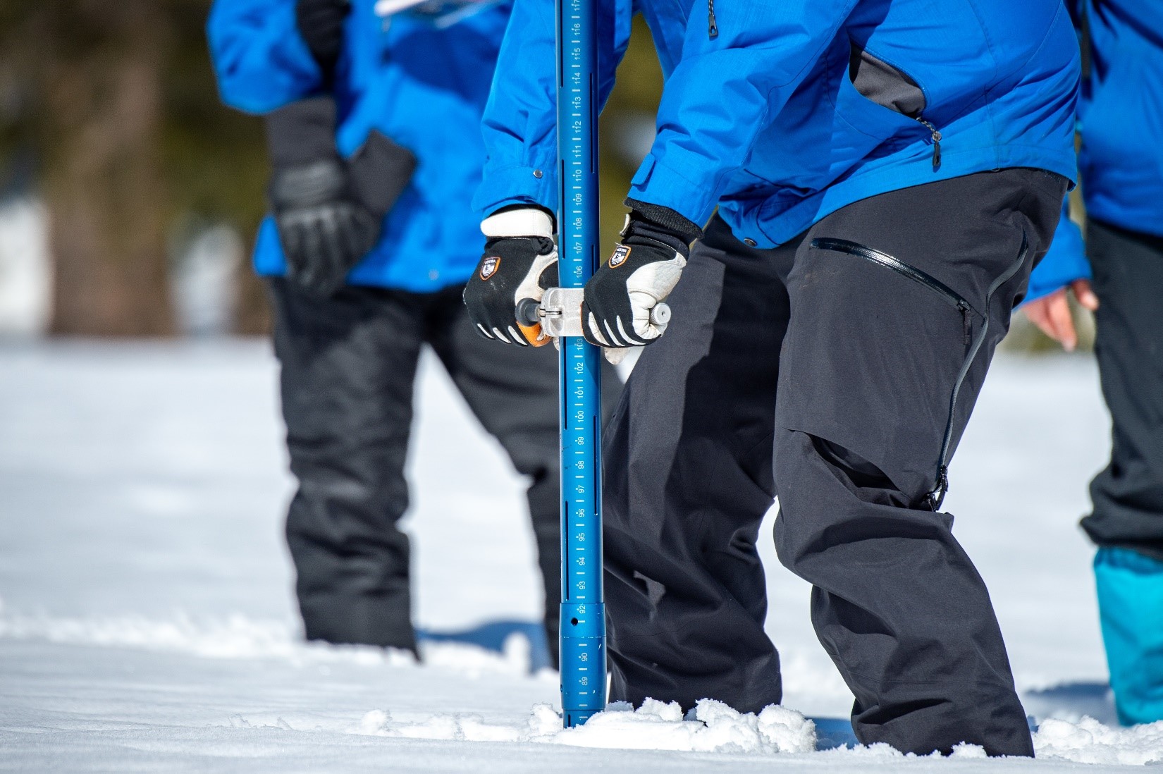
Due to the extremely deep snowpack, snow survey sampling techniques were more difficult than usual. In many cases, access to snow courses was difficult for manual snow surveys due to weather, road or trailhead closures, or avalanche safety concerns. When cooperative snow surveys teams could access snow courses, the deep snow led to the snow sampling technique called Multiple Sampling. Multiple Sampling involves extracting a snow core from a single sample point (and a single hole) in multiple, discrete steps. There is much room for error with this technique so it should only be employed when obtaining a sample with a single snow core is not an option. When reinserting the snow tube into the same hole, the snow tube can scrape the sides of the hollow core adding additional snow into the tubes. Moreover, the exposed vertical faces of the resulting snow tube hole are susceptible to cave-in which then forces snow surveyors to sample more snow than is in the actual depth of the snowpack. Due to the exceptionally deep snowpack, the multiple sampling technique was used for most snow courses throughout the year.
Hydrometeorological Station Failure
The extreme weather conditions during WY2023 exerted stress on hydrometeorological stations, leading to extensive failures and extended periods of data loss when accurate data was most needed. These stations, are designed to provide crucial information and data for the Bulletin 120, succumbed to a multitude of challenges including avalanches, electrical failures, structural deficiencies, vandalism, sensor malfunctions, and range of other unforeseen issues. The cumulative effect of these complex challenges resulted in a loss of operational capacity within the statewide monitoring network. Although it is not uncommon to lose some hydrometeorological stations during the season, the number of stations lost in WY2023 was unmatched, which emphasizes the urgency for strategic investment in hydrometeorological station maintenance, resilience, and redundancy. The repercussions of these station failures rippled through the statewide monitoring network, creating significant data gaps in the Bulletin 120 forecasting procedures. This impacted the real-time and seasonal water supply forecasting necessary for water resources management and planning.
In-situ data collection is paramount to runoff forecast accuracy. In-situ measurements include manual snow course measurements, snow sensor measurements, and other hydrometeorological sensors such as precipitation, temperature, and solar radiation located at statewide monitoring network stations. DWR began a process to upgrade its statewide monitoring network over the past 8 years including significant upgrades to the infrastructure that houses the hydrometeorological sensors. Upgrades not only include more robust and weather resistant towers but also include a wider range of hydrometeorological sensors that collect a wider range of data necessary for upgrading runoff forecast models. Upgrades to towers and infrastructure have begun and will pick up over the next several years as special use permits are issued by the USFS and NPS. The extreme weather whiplash over the past few years has underlined the need to utilize precipitation and temperature estimation models when gaps in the observation network appear. DWR continues to explore the validity of utilizing these alternate sources of data in forecasting procedures and if they are capable of providing reliable and accurate data at the frequency needed to produce the Bulletin 120 forecasts.Manual snow course measurements were pioneered in the Lake Tahoe region in the early 1900s and over the next few decades the practice was improved and perfected including the adaptation of the multiple sampling technique in heavy snowpack conditions. These methods continue to be effective during most water years, but in extreme years like WY2023 an overabundance of multi-sampling can lead to increased error as discussed previously. DWR learned from WY2023 and to attempt to collect manual snow course data on a more frequent basis during the winter to help address gaps created by inclement weather and unsafe conditions. DWR has also started to build better historical correlations between in-situ data and remotely sensed snowpack data to help estimate snowpack conditions when there are gaps in the in-situ measurements.
Lack of Accurate Spatially Explicit Snowpack Data
Despite expanded Airborne Snow Observatory data acquisition flights across the state, several Bulletin 120 watersheds were not flown due to budget limitations. Not having access to remotely sensed snowpack data such as ASO limits forecasters’ ability to compare snow input data from snow courses and snow sensors to high quality and high-resolution spatial snow water equivalent data. Other spatially explicit snow data is available, however the distributed snow data acquired from ASO is highly accurate when verified with ground-truth data and helps fill in data gaps when in-situ measurements fail or where none are located. By incorporating ASO data into the iSnobal model, the Department’s forecasters are able to understand the physical changes within the snowpack on a daily basis. This provides invaluable intelligence for forecasting to understand the snowpack accumulation, ablation, and cold content to better predict not just the volume of runoff, but also the timing of when that runoff will occur. With high quality spatially explicit snow data, the Department was able to quantify how much water was stored within the snowpack in any given watershed on any given date. This was critical intelligence information that was shared widely with partners. For example, in the San Joaquin watershed the snowpack peaked during the first week of April with approximately 3.5 million acre-feet of water contained within it. In comparison, Lake Millerton at the outlet of the San Joaquin watershed has a total reservoir capacity of 0.5 million acre-feet, which means when the snowpack was at its peak accumulation, there was enough water in the snowpack to fill Lake Millerton seven times during the snowmelt season of April through July.
In water year 2023 the following watersheds collected spatially-explicit snow data via aircraft: Upper Sacramento, Feather, Yuba, American, Tuolumne, Merced, San Joaquin, Kings, Kaweah, Kern, Truckee, and Carson. Watersheds without a Airborne Observatory flights are the Trinity, Cosumnes, Mokelumne, Stanislaus, Tule, and Walker watersheds.
The record breaking or near record breaking snowpack in WY2023 underlined the need for DWR to conduct ASO data collection and iSnobal modeling in all watersheds within Bulletin 120. In watersheds where no ASO data was available, there was greater uncertainty in how much water was contained in the snow and had the potential to exacerbate high runoff levels downstream. DWR learned much more about managing an effective statewide ASO program during WY2023 as inclement weather complicated data collection operations and the expansion of the ASO program to include more watersheds made flight planning a little more difficult. DWR also learned more about how ASO data collection and iSnobal modeling could be stood up quickly during snowmelt flood emergencies in watersheds not funded by the program budget. As was discussed in the in-situ measurement section, the value and importance of in-situ snowpack observation data was instrumental to the accuracy of the iSnobal model results used in WY2023.